


BNSF RAILWAY ...im Modellbau - Geschichte von der BNSF... von Montana (USA) in EN
Geschichte von der BNSF...
Most of Montana first came under American sovereignty with the Louisiana Purchase in 1803 and was explored by the Lewis and Clark Expedition shortly thereafter.
Fur trappers followed and were the main economic activity in the area until gold was discovered in 1852. The ensuing gold rush, along with the passage of the Homestead Acts in 1862, brought large numbers of American settlers to Montana.
Rapid population growth and development culminated in statehood on November 8, 1889. Mining, particularly around Butte and Helena, would remain the state's main economic engine through the mid-20th century.
Montana has no official nickname but several unofficial ones, most notably "Big Sky Country", "The Treasure State", "Land of the Shining Mountains", and "The Last Best Place".
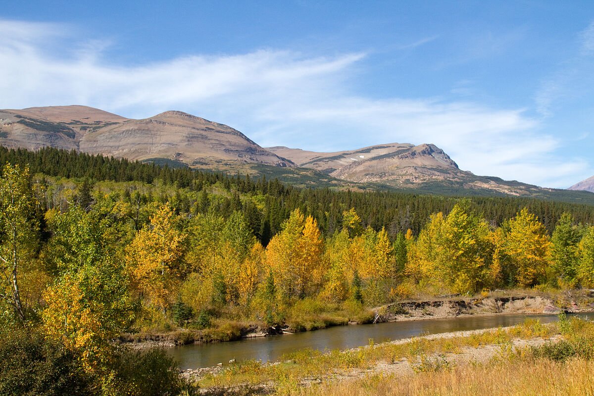
Its economy is primarily based on agriculture, including ranching and cereal grain farming. Other significant economic resources include oil, gas, coal, mining, and lumber. The health care, service, defense, and government sectors are also significant to the state's economy. Montana's fastest-growing sector is tourism, with 12.6 million tourists (as of 2019) visiting the state each year.
Etymology
The name Montana comes from the Spanish word montaña, which in turn comes from the Latin word montanea, meaning "mountain" or more broadly "mountainous country". Montaña del Norte ('Northern Mountain') was the name given by early Spanish explorers to the entire mountainous region of the west. The name Montana was added in 1863 to a bill by the United States House Committee on Territories (chaired at the time by James Ashley of Ohio) for the territory that would become Idaho Territory.
The name was changed by representatives Henry Wilson (Massachusetts) and Benjamin F. Harding (Oregon), who complained that Montana had "no meaning". When Ashley presented a bill to establish a temporary government in 1864 for a new territory to be carved out of Idaho, he again chose Montana Territory. This time, representative Samuel Cox, also of Ohio, objected to the name. Cox complained that the name was a misnomer given that most of the territory was not mountainous, and thought a Native American name would be more appropriate than a Spanish one. Other names, such as Shoshone, were suggested, but the Committee on Territories decided that they had discretion to choose the name, so the original name of Montana was adopted.
History
For thousands of years, various indigenous peoples have inhabited the land that is now Montana. Historic tribes encountered by Europeans and settlers from the United States included the Crow in the south-central area, the Cheyenne in the southeast, the Blackfeet, Assiniboine, and Gros Ventres in the central and north-central area, and the Kootenai and Salish in the west. The smaller Pend d'Oreille and Kalispel tribes lived near Flathead Lake and the western mountains, respectively. A part of southeastern Montana was used as a corridor between the Crows and the related Hidatsas in North Dakota.
As part of the Missouri River watershed, all of the land in Montana east of the Continental Divide was part of the Louisiana Purchase in 1803, except for a tiny portion in the northeast that is part of the Hudson Bay drainage. Subsequent to and particularly in the decades following the Lewis and Clark Expedition, European, Canadian and American traders operated a fur trade, trading with indigenous peoples in both eastern and western portions of the area. Though the increased interaction between fur traders and indigenous peoples frequently proved to be a profitable partnership, conflicts broke out when indigenous interests were threatened, such as the conflict between American trappers and the Blackfeet. Indigenous peoples in the region were also decimated by diseases introduced by fur traders to which they had no immunity. The trading post Fort Raymond (1807–1811) was constructed in Crow Indian country in 1807. Until the Oregon Treaty of 1846, land west of the continental divide was disputed between the British and U.S. governments and was known as the Oregon Country. The first permanent settlement by Euro-Americans in what today is Montana was St. Mary's, established in 1841 near present-day Stevensville. In 1847, Fort Benton was built as the uppermost fur-trading post on the Missouri River. In the 1850s, settlers began moving into the Beaverhead and Big Hole valleys from the Oregon Trail and into the Clark's Fork valley.
MONTANA USA | ||
  Flag Seal | ||
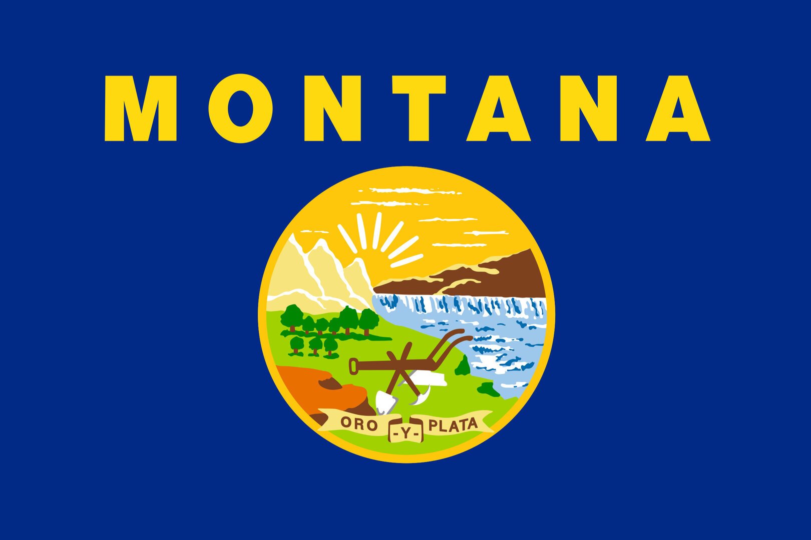
Nicknames: Big Sky Country, The Treasure State Motto(s): "Oro y Plata" (Spanish) "Gold and Silver" | ||
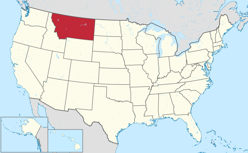 Map of the United States with Montana highlighted | ||
County | Unidet States | |
Before statehood | Montana Territory | |
Admitted to the Union | November 8, 1889 (41st) | |
Capital | Helena | |
Largest city | Billings | |
Government | ||
| Greg Gianforte (R) Kristen Juras (R) Montana Legislature | |
Judiciary | Montana Supreme Court | |
U.S. senators | Jon Tester (D) | |
U.S. House delegation |
(list) | |
| Area | ||
| 147,040 sq mi (380,800 km2) 145,552 sq mi (376,980 km2) 1,491 sq mi (3,862 km2) 1% 4th | |
| 255 mi (410 km) 630 mi (1,015 km) | |
Elevation Highest elevation (Granite Peak) Lowest elevation (Kootenai River at Idaho border) | 3,400 ft (1,040 m) 12,807 ft (3,903.5 m) 1,804 ft (557 m) | |
Dimensions | ||
Population (2022)
| 1,122,867 43rd 7.09/sq mi (2.73/km2) 48th $56,539 40th | |
Demonym | Montanan | |
Official language | English | |
Time zone
| UTC - 07:00 (Mountain) UTC - 06:00 (MDT) | |
USPS abbreviation ISO 3166 code | MT US-MT | |
Traditional abbreviation | Mont. | |
Latitude Longitude | 44° 21′ N to 49° N 104° 2′ W to 116° 3′ W | |
Mitglied seit | 8. November 1889 | |
Website | mt.gov | |
 Mao of Montana | ||
Anthem: "Montana"
State symbols of Montana | |
| Bird | |
| Butterfly | |
| Fish | |
| Flower | |
| Mammal | |
| Tree | |
| Fossil | |
| Gemstone | |
 | |
Montana territory
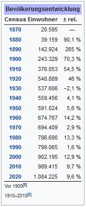
Before the creation of Montana Territory (1864–1889), areas within present-day Montana were part of the Oregon Territory (1848–1859), Washington Territory (1853–1863), Idaho Territory (1863–1864), and Dakota Territory (1861–1864). Montana Territory became a territory of the United States on May 26, 1864. The first territorial capital was located at Bannack. Sidney Edgerton served as the first territorial governor. The capital moved to Virginia City in 1865 and to Helena in 1875. In 1870, the non-Indian population of the Montana Territory was 20,595. The Montana Historical Society, founded on February 2, 1865, in Virginia City, is the oldest such institution west of the Mississippi (excluding Louisiana). In 1869 and 1870 respectively, the Cook–Folsom–Peterson and the Washburn–Langford–Doane Expeditions were launched from Helena into the Upper Yellowstone region. The extraordinary discoveries and reports from these expeditions led to the creation of Yellowstone National Park in 1872.
Conflicts
As settlers began populating Montana from the 1850s through the 1870s, disputes with Native Americans ensued, primarily over land ownership and control. In 1855, Washington Territorial Governor Isaac Stevens negotiated the Hellgate Treaty between the United States government and the Salish, Pend d'Oreille, and Kootenai people of western Montana, which established boundaries for the tribal nations. The treaty was ratified in 1859. While the treaty established what later became the Flathead Indian Reservation, trouble with interpreters and confusion over the terms of the treaty led Whites to believe the Bitterroot Valley was opened to settlement, but the tribal nations disputed those provisions. The Salish remained in the Bitterroot Valley until 1891.
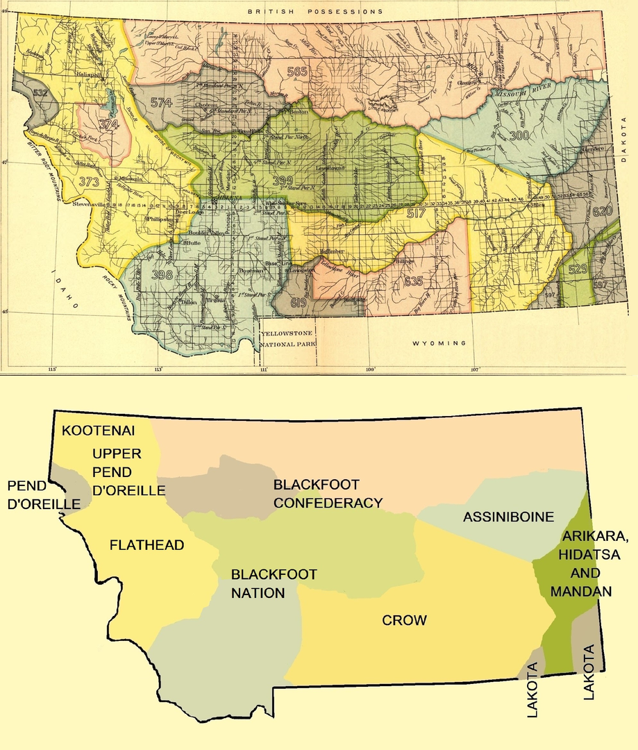 Early Indian treaty territories in Montana
The first U.S. Army post established in Montana was Camp Cooke in 1866, on the Missouri River, to protect steamboat traffic to Fort Benton. More than a dozen additional military outposts were established in the state. Pressure over land ownership and control increased due to discoveries of gold in various parts of Montana and surrounding states. Major battles occurred in Montana during Red Cloud's War, the Great Sioux War of 1876, and the Nez Perce War and in conflicts with Piegan Blackfeet. The most notable were the Marias Massacre (1870), Battle of the Little Bighorn (1876), Battle of the Big Hole (1877), and Battle of Bear Paw (1877). The last recorded conflict in Montana between the U.S. Army and Native Americans occurred in 1887 during the Battle of Crow Agency in the Big Horn country. Native survivors who had signed treaties were generally required to move onto reservations.
Simultaneously with these conflicts, bison, a keystone species and the primary protein source that Native people had survived on for many centuries, were being destroyed. Experts estimate that around 13 million bison roamed Montana in 1870.
In 1875, General Philip Sheridan pleaded to a joint session of Congress to authorize the slaughtering of bison herds to deprive Native people of their source of food.
By 1884, commercial hunting had brought bison to the verge of extinction; only about 325 bison remained in the entire United States.
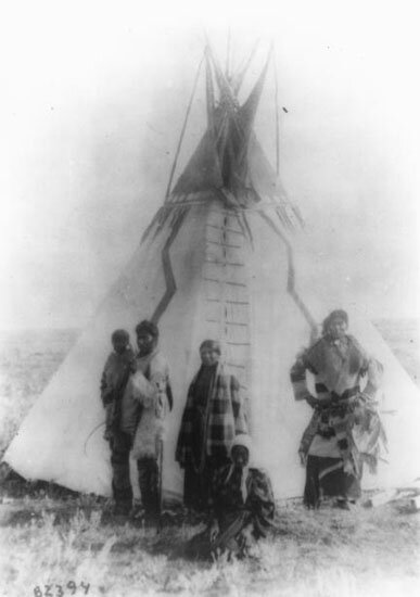 Assiniboine family, Montana, 1890–91
Cattle ranching
Cattle ranching has been central to Montana's history and economy since Johnny Grant began wintering cattle in the Deer Lodge Valley in the 1850s and traded cattle fattened in fertile Montana valleys with emigrants on the Oregon Trail. Nelson Story brought the first Texas Longhorn cattle into the territory in 1866. Granville Stuart, Samuel Hauser, and Andrew J. Davis started a major open-range cattle operation in Fergus County in 1879. The Grant-Kohrs Ranch National Historic Site in Deer Lodge is maintained today as a link to the ranching style of the late 19th century. Operated by the National Park Service, it is a 1,900-acre (7.7 km2) working ranch.
Railroads
Tracks of the Northern Pacific Railroad (NPR) reached Montana from the west in 1881 and from the east in 1882. However, the railroad played a major role in sparking tensions with Native American tribes in the 1870s. Jay Cooke, the NPR president, launched major surveys into the Yellowstone valley in 1871, 1872, and 1873, which were challenged forcefully by the Sioux under chief Sitting Bull. These clashes, in part, contributed to the Panic of 1873, a financial crisis that delayed the construction of the railroad into Montana. Surveys in 1874, 1875, and 1876 helped spark the Great Sioux War of 1876. The transcontinental NPR was completed on September 8, 1883, at Gold Creek.
In 1881, the Utah and Northern Railway, a branch line of the Union Pacific, completed a narrow-gauge line from northern Utah to Butte. A number of smaller spur lines operated in Montana from 1881 into the 20th century, including the Oregon Short Line, Montana Railroad, and Milwaukee Road.
Tracks of the Great Northern Railroad (GNR) reached eastern Montana in 1887 and when they reached the northern Rocky Mountains in 1890, the GNR became a significant promoter of tourism to Glacier National Park region. The transcontinental GNR
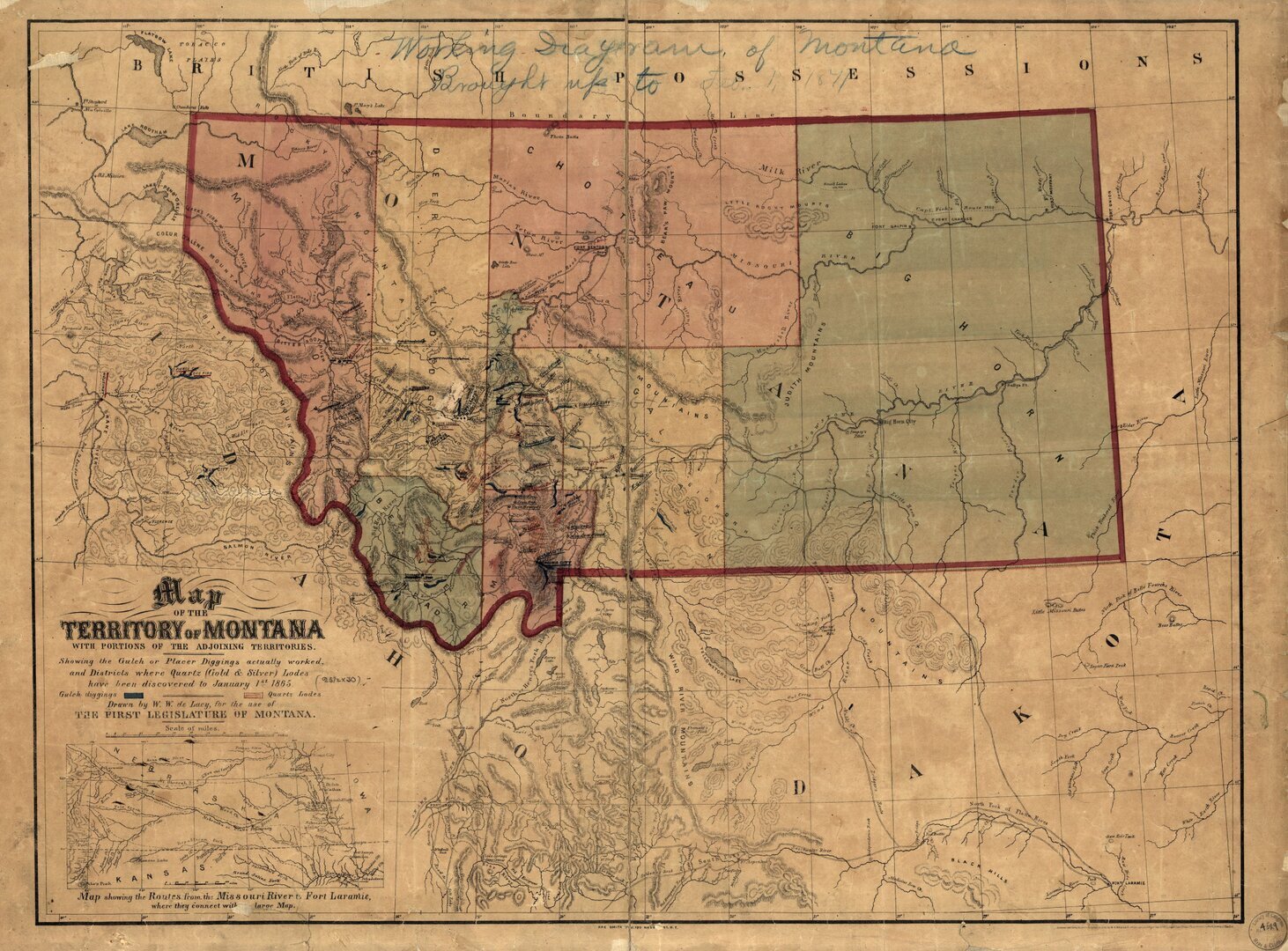 Montana Territory in 1865
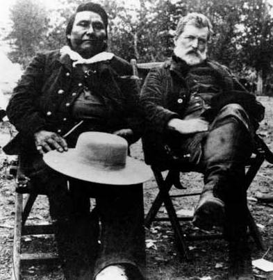
Chief Joseph and Col. John Gibbon met again on the Big Hole Battlefield site in 1889.

Buffalo Soldiers, Ft. Keogh, Montana, 1890. The nickname was given to the "Black Cavalry" by the Native American tribes they fought.
was completed on January 6, 1893, at Scenic, Washington and is known as the Hi Line, being the northern most transcontinental rail line in the United States.
Statehood
Under Territorial Governor Thomas Meagher, Montanans held a constitutional convention in 1866 in a failed bid for statehood. A second constitutional convention held in Helena in 1884 produced a constitution ratified 3:1 by Montana citizens in November 1884. For political reasons, Congress did not approve Montana statehood until February 1889 and President Grover Cleveland signed an omnibus bill granting statehood to Montana, North Dakota, South Dakota, and Washington once the appropriate state constitutions were crafted. In July 1889, Montanans convened their third constitutional convention and produced a constitution accepted by the people and the federal government. On November 8, 1889, President Benjamin Harrison proclaimed Montana the union's 41st state. The first state governor was Joseph K. Toole.
In the 1880s, Helena (the state capital) had more millionaires per capita than any other United States city.
Homesteading
The Homestead Act of 1862 provided free land to settlers who could claim and "prove-up" 160 acres (0.65 km2) of federal land in the Midwest and western United States. Montana did not see a large influx of immigrants from this act because 160 acres were usually insufficient to support a family in the arid territory. The first homestead claim under the act in Montana was made by David Carpenter near Helena in 1868. The first claim by a woman was made near Warm Springs Creek by Gwenllian Evans, the daughter of Deer Lodge Montana pioneer, Morgan Evans. By 1880, farms were in the more verdant valleys of central and western
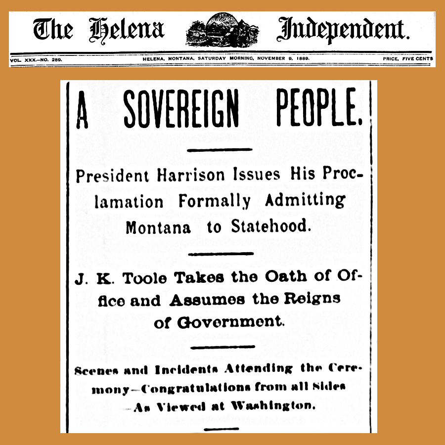 Reporting statehood from Helena: Full article text is here.
- The official telegram:
EXECUTIVE MANSION,
WASHINGTON, D.C. November 7, 1889
To Hon. Joseph K. Toole, Governor of the State of Montana:
The president signed and issued the proclamation declaring Montana a state of the union at 10:40 o'clock this morning.
JAMES G. BLAINE, Secretary of State
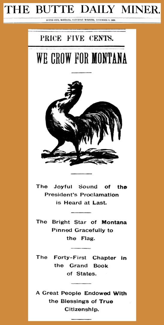 This article in a Butte newspaper celebrates "the blessings of true citizenship"
Montana, but few were on the eastern plains.
The Desert Land Act of 1877 was passed to allow settlement of arid lands in the west and allotted 640 acres (2.6 km2) to settlers for a fee of $.25 per acre and a promise to irrigate the land. After three years, a fee of one dollar per acre would be paid and the settler would own the land. This act brought mostly cattle and sheep ranchers into Montana, many of whom grazed their herds on the Montana prairie for three years, did little to irrigate the land and then abandoned it without paying the final fees.
Some farmers came with the arrival of the Great Northern and Northern Pacific Railroads throughout the 1880s and 1890s, though in relatively small numbers.
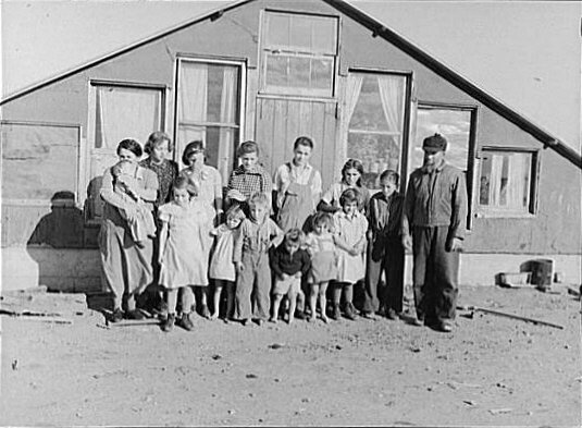 Mennonite family in Montana, c. 1937
In the early 1900s, James J. Hill of the Great Northern began to promote settlement in the Montana prairie to fill his trains with settlers and goods. Other railroads followed suit.
In 1902, the Reclamation Act was passed, allowing irrigation projects to be built in Montana's eastern river valleys. In 1909, Congress passed the Enlarged Homestead Act that expanded the amount of free land from 160 to 320 acres (0.6 to 1.3 km2) per
family and in 1912 reduced the time to "prove up" on a claim to three years.
In 1916, the Stock-Raising Homestead Act allowed homesteads of 640 acres in areas unsuitable for irrigation.
This combination of advertising and changes in the Homestead Act drew tens of thousands of homesteaders, lured by free land, with World War I bringing particularly high wheat prices. In addition, Montana was going through a temporary period of higher-than-average precipitation.
Homesteaders arriving in this period were known as "honyockers", or "scissorbills".
The word honyocker possibly derived from the ethnic slur hunyak and was applied in a derisive manner at homesteaders, who were perceived as being "greenhorns", "new at his business", or "unprepared".
However, most of these new settlers had farming experience, though many did not.
- Blackfeet Indian Reservation (Blackfeet)
- Crow Reservation (Absarokee)
- Flathead-Indianer-Reservat (Salish, Pend d’Oreille und Kutenai)
- Fort Belknap Reservation (Gros Ventre, Assiniboine)
- Fort Peck Indian Reservation (Dakota, Assiniboine)
- Northern Cheyenne Indian Reservation (Cheyenne)
- Rocky Boy’s Reservation (Cree, Chippewa)
Religionen
Die mitgliederstärksten Religionsgemeinschaften im Jahre 2000 waren
Die mitgliederstärksten Religionsgemeinschaften im Jahre 2000 waren
die Katholische Kirche mit 169.250, die Evangelisch-Lutherische Kirche in Amerika mit 50.287 und die Kirche Jesu Christi der Heiligen der Letzten Tage (Mormonen) mit 32.726 Anhängern.
Daten vom 2020
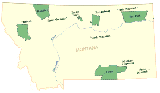 Indianerreservate in Montana
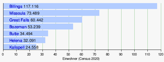
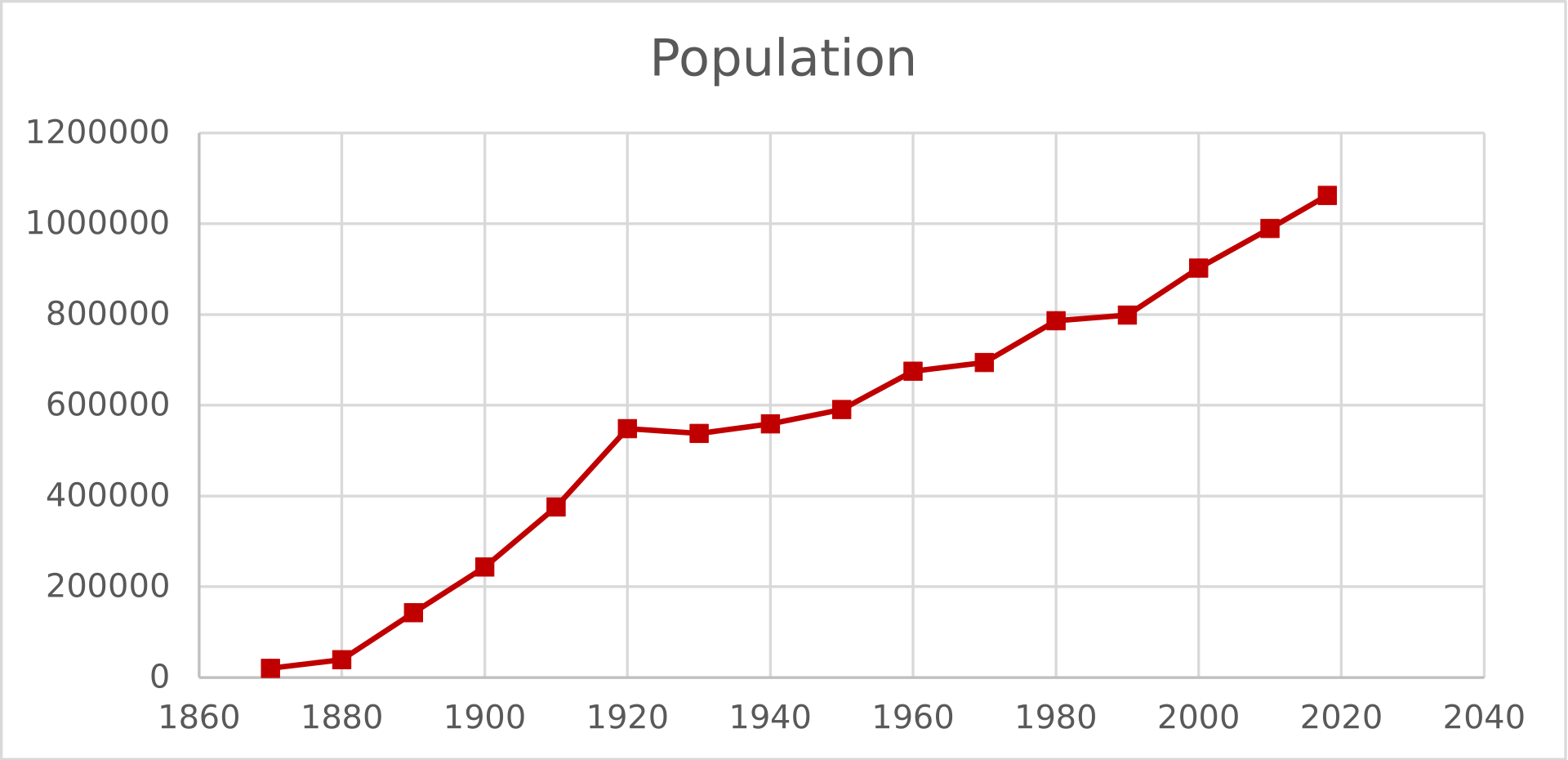 Bevölkerung Montanas 1870–2018
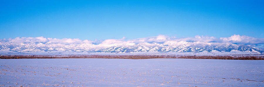 USA, Montana, Bozeman, Bridger Mountains is a photograph by Panoramic Images which was uploaded on February 4th, 2015
Geschichte
Frühgeschichte
Wie der Fund der Buhl-Frau im benachbarten Idaho zeigt, kann man in der Region mit sehr frühen, nacheiszeitlichen Bewohnern rechnen, die vor mehr als 10.000 Jahren hier auftauchten. Weiter südlich, in Boulder (Colorado), fand man im Mai 2008 83 Werkzeuge, die rund 13.000 Jahre alt sind Zu den ältesten Fundstätten im Bundesstaat zählen die Stätten von Indian Cree, Mill Iron und Myers-Hindman. Indian Creek, ein kurzzeitig bewohntes Lager, ist rund 11.000 Jahre alt, Mill Site, ein wohl nur einmal genutzter Jagd- und Speiseplatz etwa 10.700 Jahre, Myers-Hindman, ein Dauerlager rund 9000 Jahre alt. Die Barton Gulch Site im Südwesten Montanas zählt bereits zur späten paläoindianischen Epoche.
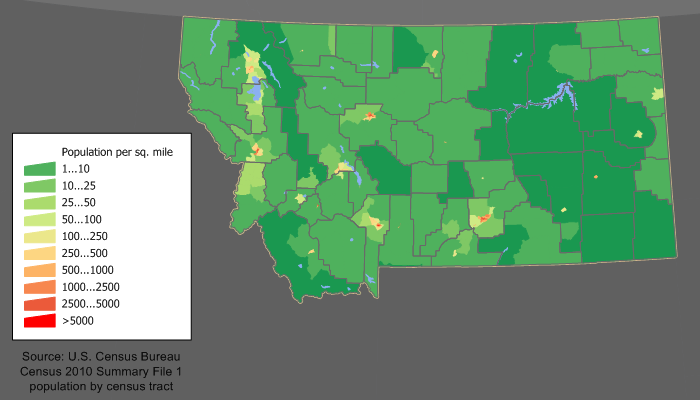 Bevölkerungsdichte 16:24, 11. Dez. 2011
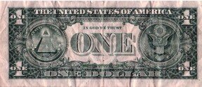
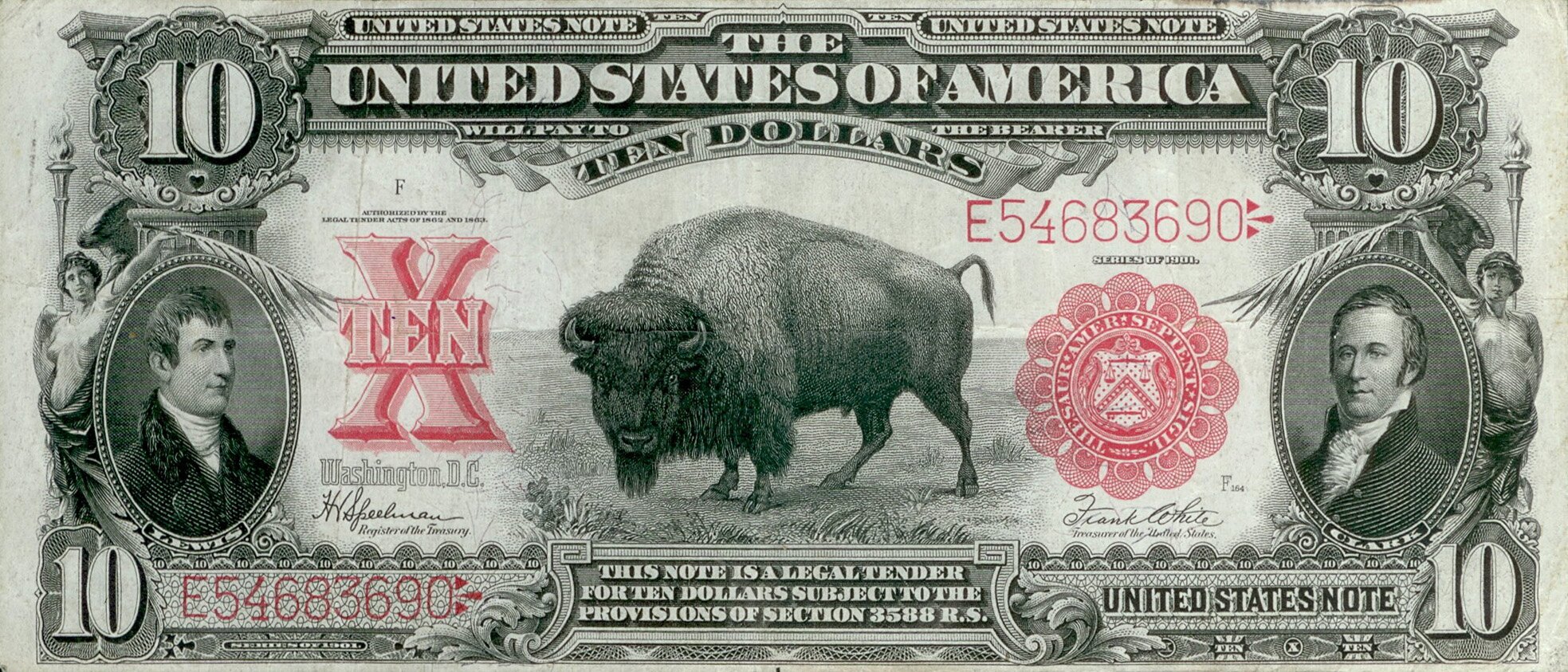 Dollarnote von 1901 mit Bison
 Madison Buffalo Jump State Park
Eine dünne Besiedlung fand während der folgenden archaischen Phase (6000 v. Chr. - 500 n. Chr.) hier und östlich der Rocky Mountains statt. Diese Phase ist durch zunehmende Trockenheit gekennzeichnet. Frühe Wickiups wurden um 3000 v. Chr. von Tipis verdrängt. Zur Jagd wurde der Atlatl eingesetzt, der um 500 durch Pfeil und Bogen ersetzt wurde. Buffalo Jumps nahmen zu, ebenso wie die Konzentration auf die als Büffel bezeichneten Bisons, die an solchen Stellen in die Tiefe gestürzt wurden. Solche Stellen finden sich am Madison Buffalo Jump oder am Ulm Pishkun. Nicht vor 1730 ersetzte das Pferd zunehmend den Hund als Transporttier, wenn auch das Travois als einfaches Transportmittel beibehalten wurde. Die heute Montana ansässigen Stämme der Indianer sind relativ spät eingewandert. Die meisten von ihnen lebten ursprünglich viel weiter östlich. Dabei haben einige von ihnen sehr komplizierte Wanderungen durchlebt. So lebten die Kutenai östlich der Rocky Mountains. Folgt man der mündlichen Tradition, so lebten sie rund 600 Jahre zuvor noch am Lake Michigan. Sie zogen auf die Tobacco Plains am Kootenai River in Montana und in British Columbia.
Die Gruppe spaltete sich in eine Obere, die Upper Kutenai, deren Lebensweise stark von der Büffeljagd beeinflusst wurde, wohingegen die Lower Kutenai sesshaft wurden. Die Jennings Band oder Agiyinik, die zu den Upper Kutenai zählte, bildete um 1850 einen Stamm von rund 700 Mitgliedern. Sie lebten zunächst um Jennings in Montana, wanderten ostwärts in die Gegend des späteren Kalispell, dann südwärts nach Elmo. Eine Gruppe, die Libby Montana zog in die Gegend um Fort Steele in British Columbia. Vor 1855 zogen die Libby und Jenning Band an den oberen Flathead Lake in Montana. Eine der ersten Gruppen, die westwärts zog, waren wohl die Blackfoot, auch wenn sie erst um 1730 Reiternomanomaden wurden. Ihre Kultur lässt sich wahrscheinlich bis ins 8. Jahrhundert zurückverfolgen. Die Salish oder Flathead, die zu den Binnen-Salish gehören, kamen eher aus Westen, wo ihre Verwandten, die Küsten-Salish, überwiegend von Fischfang lebten. Die im Hinterland lebenden Salish-Gruppen mussten sich der trockenen Landschaft auch kulturell anpassen und wurden ebenso Reiternomaden, wie ihre Nachbarn. Die Absarokee kamen erst im 18. Jahrhundert, gleichfalls von den Grossen Seen nach Montana, in dessen Süden sie lebten. Jedoch erstreckte sich ihr Gebiet sehr viel weiter nach Süden. Das Gebiet um Billings war allerdings bereits vor rund 2100 Jahren bewohnt. Die in Montana als Crow bezeichneten Absarokee (Apsáalooke) hatten wohl die grössten Pferdeherden und besassen 1914 rund 30 bis 40.000 Tiere.
Die Cheyenne wurden von den Anishinabe gleichfalls im 18. Jahrhundert verdrängt und zogen nach Dakota und Colorado.
Ähnlich erging es den Sioux, die wohl ab etwa 1650 von den Irokesen nach Westen abgedrängt worden waren, und den Gros Ventre, die um 1800, von den Cree verdrängt, nach Montana kamen. Die Assiniboine sind ein im 17. Jahrhundert abgespaltener Lakota-Stamm, der wohl ebenfalls von Irokesen westwärts verdrängt worden ist.
Bis auf die frühen Zuwanderer ist allen Gruppen gemein, dass sie von Stämmen verdrängt wurden, die gegen Pelze von Europäern mit Waffen ausgerüstet worden waren. Die Besiedlung Montanas ist eine ungewollte Fernwirkung des europäischen Handels.
Erste Europäer
Die beiden Händler Louis-Joseph und François de la Vérendrye erreichten 1743 als erste Europäer das Gebiet des heutigen Montana.
Am 30. April 1803 erwarben die USA das französische Louisiana, zu dem auch das spätere Montana gehörte. Die Lewis-und-Clark-Expedition fuhr den Columbia River hinab bis zur Pazifikküste, wo sie den Winter von 1805 auf 1806 verbrachte. Meriwether Lewis kartografierte auf der Rückreise den Marias River. William Clark hinterliess am 25. Juli 1806 seinen Namen am Pompeys Pillar rund 40 km nordöstlich von Billings. Die vierköpfige Gruppe um Lewis traf auf Blackfeet, doch kam es bei einem Streit um Waffen zu zwei Todesopfern unter ihnen. Clark betrat währenddessen das Crow-Gebiet. Ohne auch nur einen einzigen von ihnen zu Gesicht zu bekommen, stahlen sie ihnen einige Pferde.
Goldrausch und Bevölkerungswachstum
1846 überliess Grossbritannien im Zuge des Oregon-Kompromisses den USA auch den Nordwesten Montanas, das allerdings von 1861 bis 1864 Teil des Dakota-Territoriums war. 1862 begann der Goldrausch am Grasshopper Creek und später in Virginia City, und lockte tausende in das dünn besiedelte Gebiet. Bereits 1864 wurde Montana zu einem eigenständigen Territorium, Virginia City bis 1875 die Hauptstadt.
Fort Shaw wurde auf Anordnung des Kongresses 1867 westlich von Great Falls errichtet. Weitere Posten waren Camp Cooke am Judith River und Fort C.F. Smith am Bozeman Trail. Fort Shaw konnte bis zu 450 Soldaten beherbergen und bewachte bis 1891 die Versorgungslinie nach Fort Benton.
Kriege zwischen den USA und den Indianern
Die Schlacht am Little Bighorn, bei der Ende Juni 1876 in Ost-Montana eine Kavallerieeinheit von 257 Mann unter George Armstrong Custer von Lakota, Arapaho und Cheyenne aufgerieben wurde, hatte zur Folge, dass zahlreiche Cheyenne später nach Süden deportiert wurden. Doch ein Teil von ihnen kehrte unter Little Wolf nach Montana zurück.
Auf der kanadischen Seite wehrten sich die Métis unter Louis Riel bis 1884 gegen ihre Verdrängung. Einige von ihnen waren bereits um 1850 nach Dakota gezogen. Nach dem Scheitern des Aufstands kamen zahlreiche kanadische Métis nach Montana, doch erhielten sie, da sie in den Augen der Regierung keine Indianer sondern Mischlinge waren, kein Reservat. Dies betrifft bis heute den Little Shell Tribe.
Vom Territorium zum Bundesstaat
Zwischen 1864 und 1889 wurde Montana als Territorium organisiert. Es entstand aus der Umbildung des grösseren Idaho-Territoriums. Im ersten Jahr als Territorium war Bannack die Hauptstadt. Es wurde jedoch schon 1865 von Virginia City als Capitol City abgelöst. 1875 wurde die Hauptstadt nach Helena verlegt. Die Aufnahme als Bundesstaat in die USA erfolgte 1889 – Montana wurde somit 41. Bundesstaat.
Die Einstellung zu den Büffeln änderte sich ebenso wie zur Erhaltung der ökologischen Besonderheiten des Bundesstaats. 1908 entstand als erstes Schutzgebiet die National Bison Range im Westen Montanas; 1910 erfolgte auf dem drastisch redu-zierten Gebiet der Blackfeet die Gründung des Glacier-Nationalparks.
1917 zog die Republikanerin Jeannette Rankin als erste Frau in das Repräsentantenhaus der Vereinigten Staaten ein.
1973 erhielt Montana eine neue Verfassung.
1988 traf das Land die schwerste Dürrekatastrophe seit den 1930er Jahren.
Jahr | Republikaner | Demokraten | ||
2020 | 56,92 % | 343.602 | 40,55 % | 244.786 |
2016 | 55,65 % | 279.240 | 35,41 % | 177.709 |
2012 | 55,30 % | 267.928 | 41,66 % | 201.839 |
2008 | 49,49 % | 243.882 | 47,11 % | 232.159 |
2004 | 59,07 % | 266.063 | 38,56 % | 173.710 |
2000 | 58,44 % | 240.178 | 33,36 % | 137.126 |
1996 | 44,11 % | 179.652 | 41,23 % | 167.922 |
1992 | 35,12 % | 144.207 | 37,63 % | 154.507 |
1988 | 52,07 % | 190.412 | 46,20 % | 168.936 |
1984 | 60,47 % | 232.450 | 38,18 % | 146.742 |
1980 | 56,82 % | 206.814 | 32,43 % | 118.032 |
1976 | 52,84 % | 173.703 | 45,40 % | 149.259 |
1972 | 57,93 % | 183.976 | 37,85 % | 120.197 |
1968 | 50,60 % | 138.835 | 41,59 % | 114.117 |
1964 | 40,57 % | 113.032 | 58,95 % | 164.246 |
1960 | 51,10 % | 141.841 | 48,60 % | 134.891 |
1956 | 57,13 % | 154.933 | 42,87 % | 116.238 |
Politik
Der Gouverneur ist das Regierungsoberhaupt, wird alle vier Jahre von den Wahlberechtigten gewählt, eine Wiederwahl ist möglich. Nach zwei unmittelbar aufeinanderfolgende Amtszeiten ist eine Unterbrechung vor einer erneuten Wiederwahl notwendig. Weitere durch Wahl bestimmte Posten sind die des Vizegouverneurs (Lieutenant Governor), des Staatsministers (Secretary of State), des Generalstaatsanwalts (Attorney General), des Kultusministers (Superintendent of Public Instruction) sowie des Rechnungsprüfers (Auditor). Der gegenwärtige Gouverneur ist Greg Gianforte (* 1961, Republikaner).
Der Senat von Montana (50 Mitglieder gewählt auf vier Jahre) und das Repräsentantenhaus von Montana (100 Mitglieder gewählt auf zwei Jahre) bilden zusammen das Zweikammernsystem der Legislative. Auf nationaler Ebene wird Montana durch zwei Senatoren und einen Abgeordneten des Repräsentantenhauses vertreten. Als dünn besiedelter Bundesstaat hat Montana bei den Präsidentenwahlen nur drei Wahlmännerstimmen. Die zwei gegenwärtigen US-Senatoren aus Montana sind der Demokrat Jon Tester und der Republikaner Steve Daines. Abgeordneter im US-Repräsentantenhaus ist der Republikaner Matt Rosendale.
Traditionell werden in Montana bei den Präsidentschafts- und Gouverneurswahlen meist die Republikaner bevorzugt, während die Demokraten bei den Wahlen zum Kongress mehr Stimmen erhalten. Herausragende politische Persönlichkeiten aus Montana waren Mike Mansfield (1903–2001) und Jeannette Rankin (1880–1973). Mansfield war von 1961 bis 1977 demokratischer Mehrheitsführer im US-Senat und später US-Botschafter in Japan. Rankin war die erste Frau, die in das Repräsentantenhaus gewählt wurde; dort vertrat sie konsequent ihre pazifistische Einstellung und stimmte sowohl während des Ersten als auch während des Zweiten Weltkrieges gegen den Kriegseintritt der USA.
 Dollarnote von 2003
Mitglieder im 117. Kongress
Zwischen 1990 und 2021 entsandte der Bundesstaat nur einen Abgeordneten in das US-Repräsentantenhaus nach Washington, D.C. Im Jahr 2021 erhielt Montana aufgrund seiner gewachsenen Bevölkerung einen zweiten Sitz im Repräsentantenhaus zugeteilt. Seither ist der Bundesstaat in zwei Kongresswahlbezirke (congressional districts) eingeteilt: den 1.
Kongresswahlbezirk (westlich, das Vorland der Rocky Mountains) und den 2. Kongresswahlbezirk (östlich, die Ebenen). Die Wählerschaft des 1. Kongresswahlbezirks gilt traditionell als etwas liberaler eingestellt als die des 2. Wahlbezirks.
Ergebnisse der Präsidentschaftswahlen
Gouverneure
Montana-Territorium
Diese Liste führt alle Gouverneure des US-Bundesstaates Montana und des zuvor bestehenden Montana-Territoriums auf.
Montana-Territorium
Diese Liste führt alle Gouverneure des US-Bundesstaates Montana und des zuvor bestehenden Montana-Territoriums auf.
Name | Amtszeit | Partei |
Sidney Edgerton | 1864-1865 | Republikaner |
Thomas Francis Meagher | 1865-1866 | Demokrat |
Green Clay Smith | 1866-1868 | Demokrat |
James Tufts | 1868-1869 | Republikaner |
James Mitchell Ashley | 1869 | Republikaner |
Wiley S. Scribner | 1869-1870 | |
Benjamin Franklin Potts | 1870-1883 | Republikaner |
John Schuyler Crosby | 1883-1884 | Republikaner |
BenjaminPlatt Carpenter | 1884-1885 | Republikaner |
Samuel Thomas Hauser | 1885-1887 | Demokrat |
Preston Hopkins Leslie | 1887-1899 | Demokrat |
Benjamin Franklin White | 1889 | Republikaner |
 Bild 1 (2021): Greg Gianforte, der derzeitige Gouverneur von Montana (seit 2021)
Bundesstaat Montana
Diese Liste führt alle Gouverneure des US-Bundesstaates Montana und des zuvor bestehenden Montana-Territoriums auf.
Name | Amtszeit | Partei |
Joseh Kemp Toole | 1889-1893 | Demokrat |
John Ezra Rickards | 1893-1897 | Republikaner |
Robert Burns Smith | 1897-1901 | Demokrat |
Joseph Kemp Toole | 1901-1908 | Demokrat |
Edwin Lee Norris | 1908-1913 | Demokrat |
Samuel Vernon Stewart | 1913-1921 | Demokrat |
Joseph Moore Dixon | 1921-1925 | Republikaner |
John Edward Erickson | 1925-1933 | Demokrat |
Frank Henry Cooney | 1933-1935 | Demokrat |
Wiliam Elmar Holt | 1935-1937 | Demokrat |
Roy Elmer Ayers | 1937-1941 | Demokrat |
Samuel Clarence Ford | 1941-1949 | Republikaner |
John Woodrow Bonner | 1949-1953 | Demokrat |
John Hugo Aronson | 1953-1961 | Republikaner |
Donald Grant Nutter | 1961-1962 | Republikaner |
Tim Milford Babcock | 1962-1969 | Republikaner |
Forrest Howard Anderson | 1969-1973 | Demokrat |
Forrest Howard Anderson | 1973-1981 | Demokrat |
Theodore Schwinden | 1981-1989 | Demokrat |
Stanley Graham Stephens | 1989-1993 | Republikaner |
Marc F. Racicot | 1993-2001 | Republikaner |
Judy Martz | 2001-2005 | Republikaner |
Brain David Schweitzer | 2005-2013 | Demokrat |
Steve Bullock | 2013-2021 | Demokrat |
Gregory Richard Gianforte | seit 2021 | Republikaner |
Liste der Vizegouverneure von Montana
Das Amt des Vizegouverneurs wurde im US-Bundesstaat Montana mit der Staatsgründung im Jahr 1889 geschaffen. Der Vizegouverneur vertritt den Gouverneur in dessen Abwesenheit.
Bundesstaat Montana
Name | Amtszeit | Partei |
Ted James | 1965-1969 | Republikaner |
Thomas Lee Judge | 1969-1973 | Demokrat |
Bill Christiansen | 1973-1977 | Demokrat |
Theodore Schwinden | 1977-1981 | Demokrat |
George Turman | 1981-1988 | Demokrat |
Gordon McOmber | 1988-1989 | Demokrat |
Allen Kolstad | 1989-1993 | Republikaner |
Dennis Rehberg | 1993-1997 | Republikaner |
Judy Martz | 1997-2001 | Republikaner |
Karl Ohs | 2001-2005 | Republikaner |
John Bohlinger | 2005-2013 | Republikaner |
John Walsh | 2013-2014 | Demokrat |
Angela McLean | 2014–2016 | Demokrat |
Mike Cooney | seit 2016 | Demokrat |
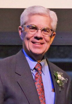
Bild von 2017: Mike Cooney (Michael R. „Mike“ Cooney) - Demokrat, derzeitiger Vizegouverneurin von Montana (seit 2016)
Name | Amtszeit | Partei |
John Rickards | 1889-1893 | Republikaner |
Alexander Campell Botkin | 1893-1897 | Republikaner |
A. E. Spriggs | 1897-1901 | Demokrat |
Frank G. Higgins | 1901-1905 | Demokrat |
Edwin L. Norris | 1905-1908 | Demokrat |
Benjamin Franklin White | 1908-1909 | Republikaner |
William R. Allen | 1909-1913 | Republikaner |
W. W. McDowell | 1913-1921 | Demokrat |
Nelson Story | 1921-1925 | Republikaner |
W. S. McCormack | 1925-1929 | Republikaner |
Frank A. Hazelbaker | 1929-1933 | Republikaner |
Frank Henry Cooney | 1933 | Demokrat |
Tom Kane | 1933-1935 | Republikaner |
Ernest T. Eaton | 1935 | Republikaner |
William Elmer Holt | 1935 | Demokrat |
William P. Pileram | 1935-1937 | Demokrat |
Hugh R. Adair | 1937-1941 | Demokrat |
Ernest T. Eaton | 1941-1949 | Republikaner |
Paul C. Cannon | 1949-1953 | Demokrat |
Georg M. Gosman | 1953-1957 | Republikaner |
Paul C. Cannon | 1957-1961 | Demokrat |
Tim Milford Badcock | 1961-1962 | Republikaner |
David F. James | 1962-1965 | Demokrat |
 Bild von 2015: Mike Cooney (Michael R. „Mike“ Cooney) - Demokrat, derzeitiger Vizegouverneurin von Montana (seit 2016)
Repräsentantenhaus | |||
Name | Mitglied seit | Parteizuge-hörigkeit | |
Matthew „Matt“ Martin Rosendale Sr. | 2021 | Republikaner | |
Ryan Zinke | 2021 | Republikaner | |
Senat | |||
Name | Mitglied seit | Parteizuge-hörigkeit | |
Raymond Jonathan „Jon“ Tester | 2007 | Demokrat | |
Steven David „Steve“ Daines | 2015 | Republikaner | |
 Matt Rosendale (2021)
 Jon Tester (2014)
 Ryan Zinke (2017)
 Steve Daines (2019)
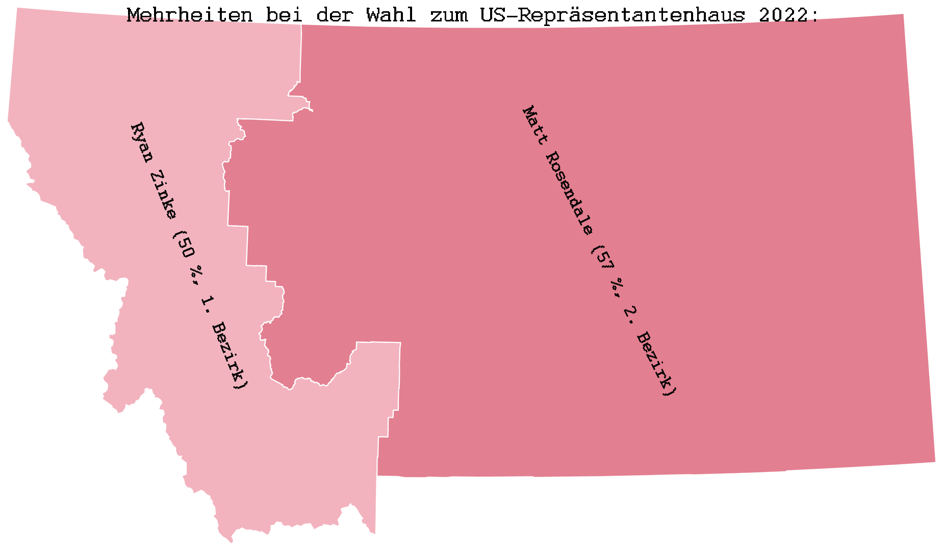
Mehrheiten bei der Wahl zum US-Repräsentantenhaus 2022:
Kongress
Liste der Senatoren der Vereinigten Staaten aus Montana
Liste der Senatoren der Vereinigten Staaten aus Montana
Die Liste der Senatoren der Vereinigten Staaten aus Montana führt alle Personen auf, die jemals für diesen Bundesstaat dem Senat angehörten, nach den Senatsklassen sortiert. Dabei zeigt eine Klasse, wann dieser Senator wiedergewählt wird. Die Wahlen der Senatoren der class 1 fanden 2006 statt und werden erst wieder 2012 stattfinden. Die Senatoren der class 2 wurden im November 2008 wiedergewählt.
Klasse 1
Montana ist seit dem 8. November 1889 US-Bundesstaat und hatte bis heute zwölf Senatoren der class 1 im Kongress.
Klasse 2
Montana stellte bis heute zehn Senatoren der class 2.
Name | Amtszeit | Partei | Lebensdaten |
Wilbur Fiske Sanders | 1890-1893 | Republikaner | 02.Mai 1834 - 07.Juli 1905 |
Vakant (1893 - 1895) | |||
Lee Mantle | 1895-1899 | Republikaner | 13.Dez. 1851 |
William Andrews Clark | 1899-1900 | Demokrat | 08.Jan. 1839 - 02.Mrz. 1925 |
Paris Gibson | 1901-1905 | Demokrat | 01.Jul. 1830 - 16.Dez. 1920 |
Thomas Henry Carter | 1905-1911 | Republikaner | 30.Okt. 1854 - 17.Sept. 1911 |
Henry Lee Myers | 1911-1923 | Demokrat | 09.Okt.1862 - 11.Nov. 1943 |
Burton Kendall Wheeler | 1923-1947 | Demokrat | 27.Feb. 1882 - 06.Jan. 1975 |
Zales Nelson Ecton | 1947-1953 | Republikaner | 01.Apr. 1898 - 03.Mrz. 1961 |
Michael Joseph Mansfield | 1953-1977 | Demokrat | 16.Mrz. 1903 - 05.Okt. 2001 |
John Melcher | 1977-1989 | Demokrat | 06.Sept. 1924 – 12. April 2018 |
Conrad Ray Burns | 1989-2007 | Republikaner | 25.Jan. 1935 - 28. April 2016 |
Raymond Jonathan „Jon“ Tester | seit 2007 | Demokrat | * 21.Aug. 1956 |
Name | Amtszeit | Partei | Lebensdaten |
Thomas Charls Power | 1890-1895 | Republikaner | 22.Mai 1939 - 16.Feb. 1923 |
Thomas Henry Carter | 1895-1901 | Republikaner | 30.Okt. 1854 - 17.Sept. 1911 |
Williams Andrews Clark | 1901-1907 | Demokrat | 08.Jan. 1839 - 02.Mrz. 1925 |
Joseph Moore Dixon | 1907-1913 | Republikaner | 31.Jul. 1867 - 22.Mai 1934 |
Thomas James Walsh | 1913-1933 | Demokrat | 12.Jun. 1859 - 02.Mrz. 1933 |
John Edward Erickson | 1933-1934 | Demokrat | 14.Mrz. 1863 - 25.Mai 1946 |
James Edward Murray | 1934-1961 | Demokrat | 03.Mai 1876 - 23.Mrz. 1961 |
Lee Warren Metcalf | 1961-1978 | Demokrat | 28.Jan. 1911 - 12.Jan. 1978 |
Paul Gerhart Hartfield | 1978 | Demokrat | 29.Apr. 1928 - 03.Jul. 2000 |
Max Sieben Baucus | 1978-1974 | Demokrat | 11.Dez. 1941 |
John E. Walsh | 2014-2015 | Demokrat | 03.Nov. 1960 |
Steven David Daines | seit 2015 | Republikaner | 20.Aug. 1962 |

Siegel des Repräsentantenhauses der Vereinigten Staaten
Kultur und Sehenswürdigkeiten
Herausragende Sehenswürdigkeiten sind vor allem die beiden Nationalparks, der Glacier-Nationalpark im Norden und der Yellowstone-Nationalpark im Süden. Andere Touristenattraktionen sind das Little Bighorn Battlefield National Museum, die frühere Hauptstadt von Montana Virginia City, die Geisterstadt Nevada City, die Grant-Kohrs Ranch National Historic Site und das Museum für die Geschichte der Prärieindianer in Browning.
Nationalparks
Nationalpark | Lage | Ansicht |
Glacier-Nationalpark (Vereinigte Staaten) • Montana • 2.031.348 Besucher (2009) • gegründet 11. Mai 1910 |  |  |
Yellowstone-Nationalpark • Wyoming , Montana, Idaho • 2.835.651 Besucher (2005) • gegründet 1. März 1872 |  |  |
Natur- und Kulturdenkmäler
Persönlichkeiten
- Big Hole National Battlefield
- Bighorn Canyon National Recreation Area
- Grant-Kohrs Ranch National Historic Site
- Lewis & Clark National Historic Trail
- Little Bighorn Battlefield National Monument
- Pompeys Pillar National Monument
- Upper Missouri River Breaks National Monument
- Gary Cooper, Schauspieler und Oscarpreisträger
- Phil Jackson, Basketballtrainer
- David Lynch, Regisseur und Drehbuchautor
- Brannon Braga, Drehbuchautor und Filmproduzent
- Jeannette Rankin, Politikerin und Pazifistin
- Charles M. Russell, Maler
- Evel Knievel, Stuntman
- Myrna Loy, Schauspielerin
- Lester C. Thurow, Wirtschaftswissenschaftler
- Kathy Tyers, Schriftstellerin
- Levi Leipheimer, Radrennfahrer
- Christopher Paolini, Schriftsteller
- Dirk Benedict, Schauspieler
- Jack Horner, Paläontologe
Sport
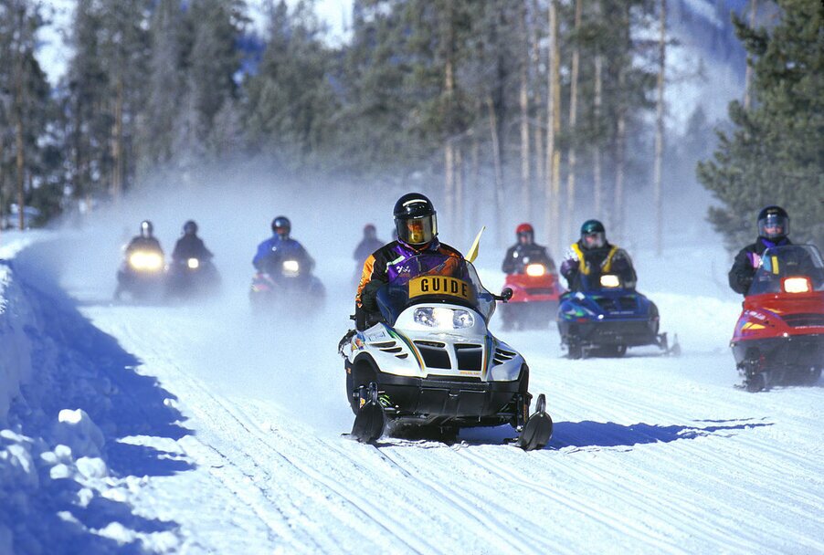
In den USA populäre Sportarten wie Baseball werden auch in Montana betrieben, und es gibt eine Reihe von Teams, die in der Minor League spielen. Grosse Bedeutung besitzen Natur- oder Outdoor-Sportarten wie Wandern, Fischen, Jagen und Klettern. Im Winter ist der Skisport populär. Es gibt 16 Skigebiete; die zwei bekanntesten sind wohl Bridger Bowl bei Bozeman und das Red Lodge Mountain Resort bei Red Lodge.


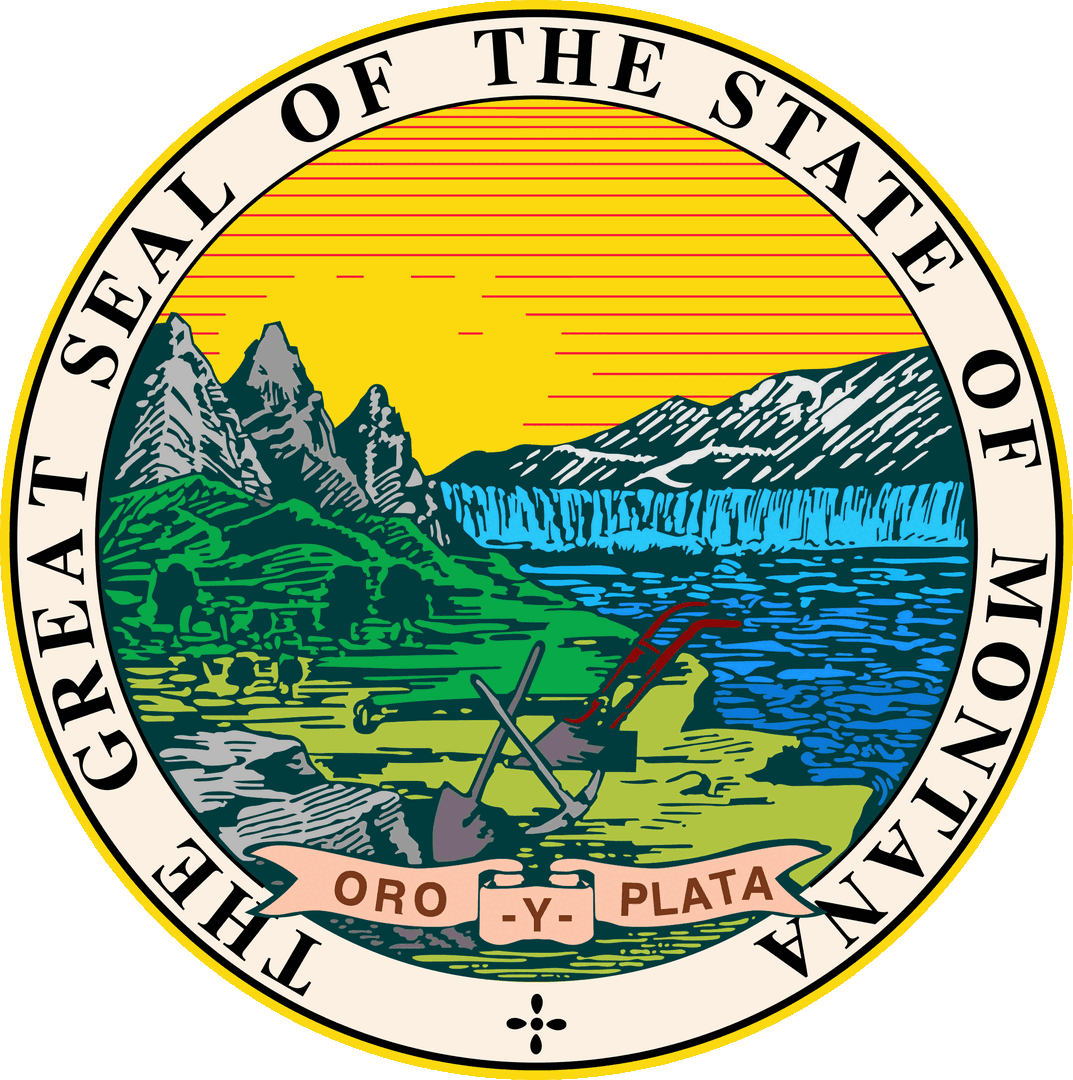
The Great Seal of the State of Montana
Wirtschaft und Infrastruktur
Das reale Bruttoinlands-produkt pro Kopf (engl. per capita real GDP) lag im Jahre 2006 bei USD 27.942(nationaler Durchschnitt der 50 US-Bundesstaaten:
Flagge von Bundesstaat Montana
USD 57.118; nationaler Rangplatz: 43). Die Arbeitslosenrate lag im November 2017 bei 4,0 % (Landesdurchschnitt: 4,1 %).
Montana ist reich an Bodenschätzen und anderen natürlichen Ressourcen. Zu den wichtigsten Rohstoffvorkommen zählen Kupfer, Gold, Silber, Edelsteine, Vermiculit, Talkum, Tonerden, Antimon, Kalkstein, Phosphat, Gips, Steine, Sand und Kies. Allerdings sind viele Minen heute erschöpft. Die Kupfermine von Butte wurde 1983 geschlossen und zog eines der grössten Projekte zur Beseitigung von Bergschäden in den USA nach sich. Die Kupferhütte in Anaconda stellte 1980 den Betrieb ein. Viele Arbeitskräfte in Bergbau und Industrie verloren dadurch ihre Arbeitsplätze, Montana wurde tendenziell zur Niedriglohnregion.
Von grosser Bedeutung sind heute die Vorkommen an Erdöl, Erdgas und Kohle. So basiert der Grossteil der Industrieproduktion auf der Verarbeitung der geförderten Rohstoffe (Erdöl- und Kohleprodukte, Erzverhüttung, chemische Erzeugnisse, Metallprodukte). Die Landwirtschaft ist jedoch der wichtigste Erwerbszweig. Im Nordosten und im Zentrum von Montana werden Weizen, Mais und Gerste angebaut, während im Süden Rinder- und Viehzucht betrieben wird. Auch Wein wird angebaut. Es existieren zahlreiche Kleinbrauereien. Die Forstwirtschaft floriert vor allem im Nordwesten des Landes, wenn sich auch grosse Teile der Nutzwälder in staatlicher Hand befinden.
Viele Farmen wurden in den letzten Jahrzehnten aufgeteilt und als Ferienimmobilien oder Zweitwohnsitze verkauft. Der Tourismus (mit Golfplätzen, Winter-sportmöglichkeiten, Jagd und Fischfang) spielt seit den 1980er Jahren eine wachsende Rolle.
Bildung
Die wichtigsten staatlichen Universitäten sind in dem Montana State University System mit Hauptstandort in Bozeman und dem University of Montana System mit Hauptstandort in Missoula zusammengefasst. Weitere Hochschulen sind in der Liste der Universitäten in Montana verzeichnet.
03. Juni 2009
14. Juni 2009
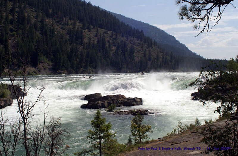
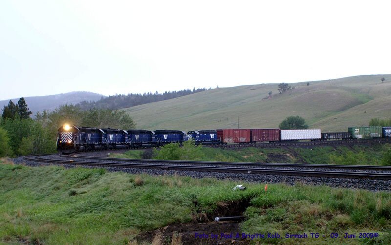 09. Juni 2009
Alle diese Fotos by Paul & Brigitte Kolb, Sirnach TG - 2009©
>>> EIN HERZLICHES DANKESCHÖN FÜR DIE ZURVERFÜGUNGSTELLEN DER CA. 600 FOTOS VON DEN MONTANA REISEN! <<<
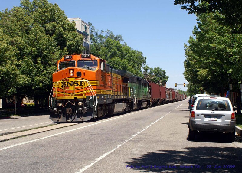
22. Juni 2009
Verkehr
Strasse
Strasse
Die wichtigsten Strassenverbindungen sind die Interstate 90 und die Interstate 94, die U.S. Routes 2 und 12 sowie der durch Montana in Ost-West-Richtung verlaufende Montana Highway 200, der mit 707 Meilen (oder 1137 km) die längste State Route der USA ist.
Montana war zusammen mit Nevada einer von zwei US-Bundesstaaten, in denen es vor 1974 sowie zwischen 1995 und 1999 keine Geschwindigkeitsbegrenzung auf einigen Highways in dünn besiedelten Gebieten gab.
Eisenbahn
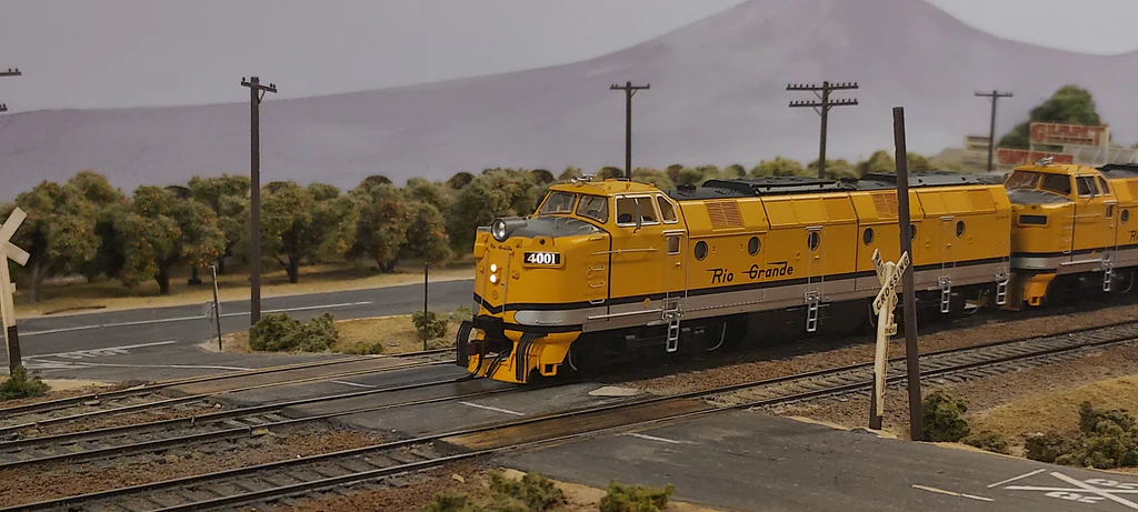
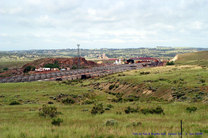
1883 wurde die kontinentale Ost-West-Verbindung der Northern Pacific Railroad, die durch Billings führt, fertiggestellt. Die Strecke wird heute von den Güterzügen der BNSF Railway genutzt.
Luftverkehr
Ein internationaler Flughafen, Billings Logan International Airport, befindet sich in Billings. Seit 2013 weist jedoch der Bozeman Yellowstone International Airport mehr Verkehrsbewegungen auf, auch wenn er trotz seines Namens nur mit inländischen Zielen verbunden ist.
Militär
Auf dem Territorium des Staates sind 150 nukleare Interkontinentalraketen des Typs Minuteman III der 341st Missile Wing (US Air Force) stationiert, die sich in ständiger Einsatzbereitschaft befinden. Hauptquartier ist die Malmstrom Air Force Base.
Sonstiges
Die Flagge von Montana zeigt das Siegel des Bundesstaates auf blauem Grund. Sie entstand aus einer Truppenfahne, die ursprünglich von Freiwilligenverbänden im Spanisch-Amerikanischen Krieg von 1898 benutzt wurde. Die Flagge in ihrer jetzigen Form stammt aus dem Jahr 1905, der Name „Montana“ wurde jedoch erst 1981 hinzugefügt.
Nach dem Bundesstaat ist die Montana-Klasse der US Navy benannt.
Offizielle Symbole
Der Wahlspruch Montanas lautet Oro y Plata, oder Gold and Silver. Montana hat sich zahlreiche offizielle Symbole gegeben. Einige davon sind in der folgenden Tabelle aufgeführt.
Symbol | Abbildung | Annahme als Staatssymbol | Anmerkungen | |
Siegel | Siegel Montanas | | 1893 | In sehr ähnlicher Form war das Siegel bereits 1865 als Siegel des Montana-Territoriums angenommen worden. |
Flagge | Flagge Montanas | | 1905 | Schon 1898 als Truppenfahne von Freiwilligenverbänden aus Montana im Spanisch-Amerikanischen Krieg benutzt. Das Wort „Montana“ oberhalb des Siegels wurde 1981 hinzugefügt. 1985 wurde die Schriftart von „Montana“ festgelegt. |
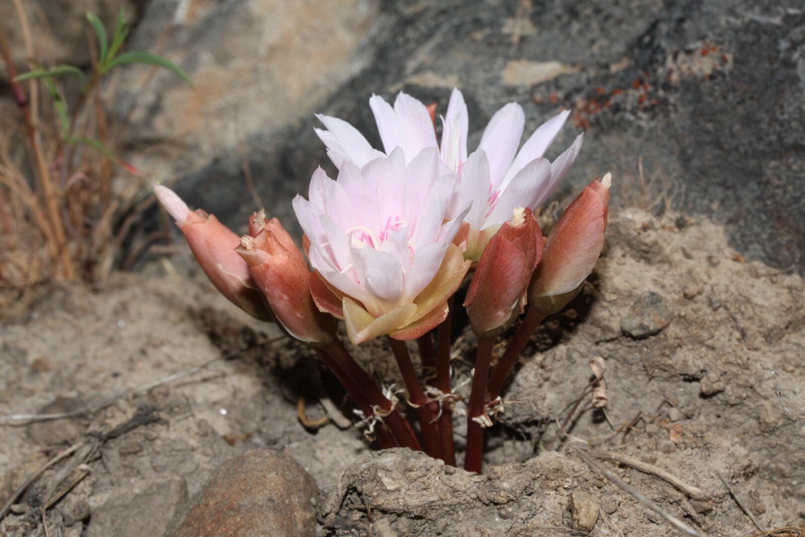
Blume | Bitterwurz Bitterroot Lewisia rediviva |  | 1895 | 1894 wurde eine Kampagne zur Nominierung einer Blume als Staatssymbol durch die Women’s Christian Temperance Union eine Temperenzlerorganisation von Frauen in Montana angestoßen. Der Hintergedanke der Kampagne war es auch, Frauen in der politischen Organisation und Betätigung zu üben und sie später für den Kampf um das Frauenwahlrecht zu gewinnen. Der Bitterwurz kommt praktisch nur im Westen Montanas vor, wo damals der Großteil der Bevölkerung lebte. |
Vogel | Westlicher Lerchenstärling Western Meadowlark Sturnella neglecta |  | 1931 | Der Westliche Lerchenstärling ist ein bodenbrütender Singvogel, der über den ganzen Westen der Vereinigten Staaten verbreitet ist. Der Vogel wurde 1930 durch eine Abstimmung unter Schulkindern zum Staatsvogel Montanas gewählt, was im Folgejahr durch die Legislative Montanas gesetzlich verankert wurde. |
Baum | Ponderosa-Kiefer Ponderosa Pine (Pinus ponderosa) | 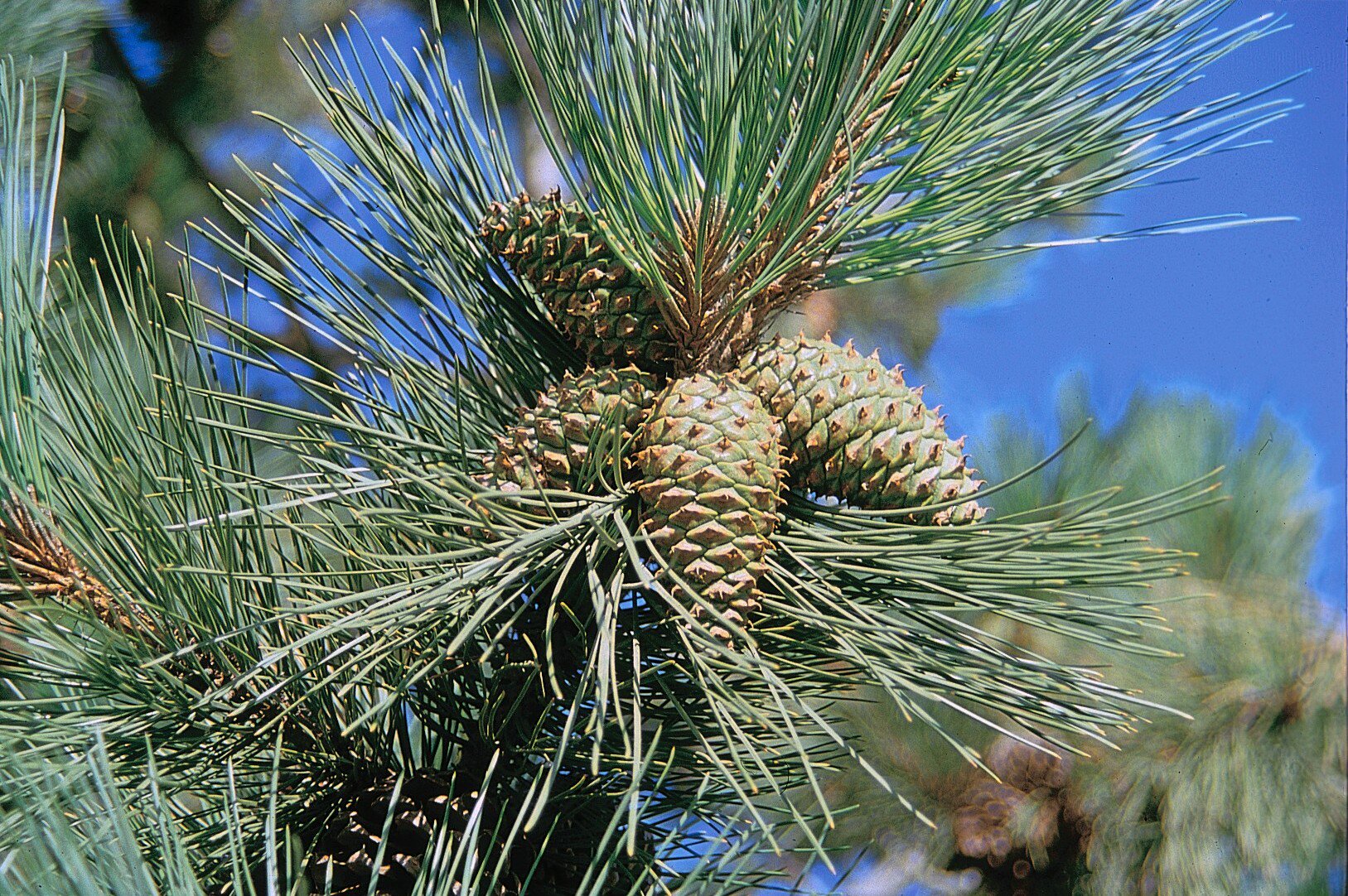 | 1949 | |
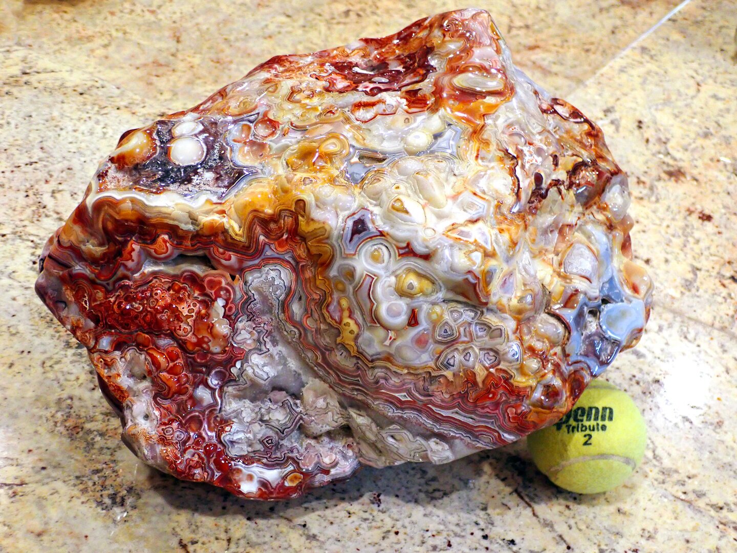
Schmuckstein | Saphir und Achat | 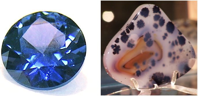 | 1969 | |
Gras | Pseudoroegneria spicata Bluebunch Wheatgrass | 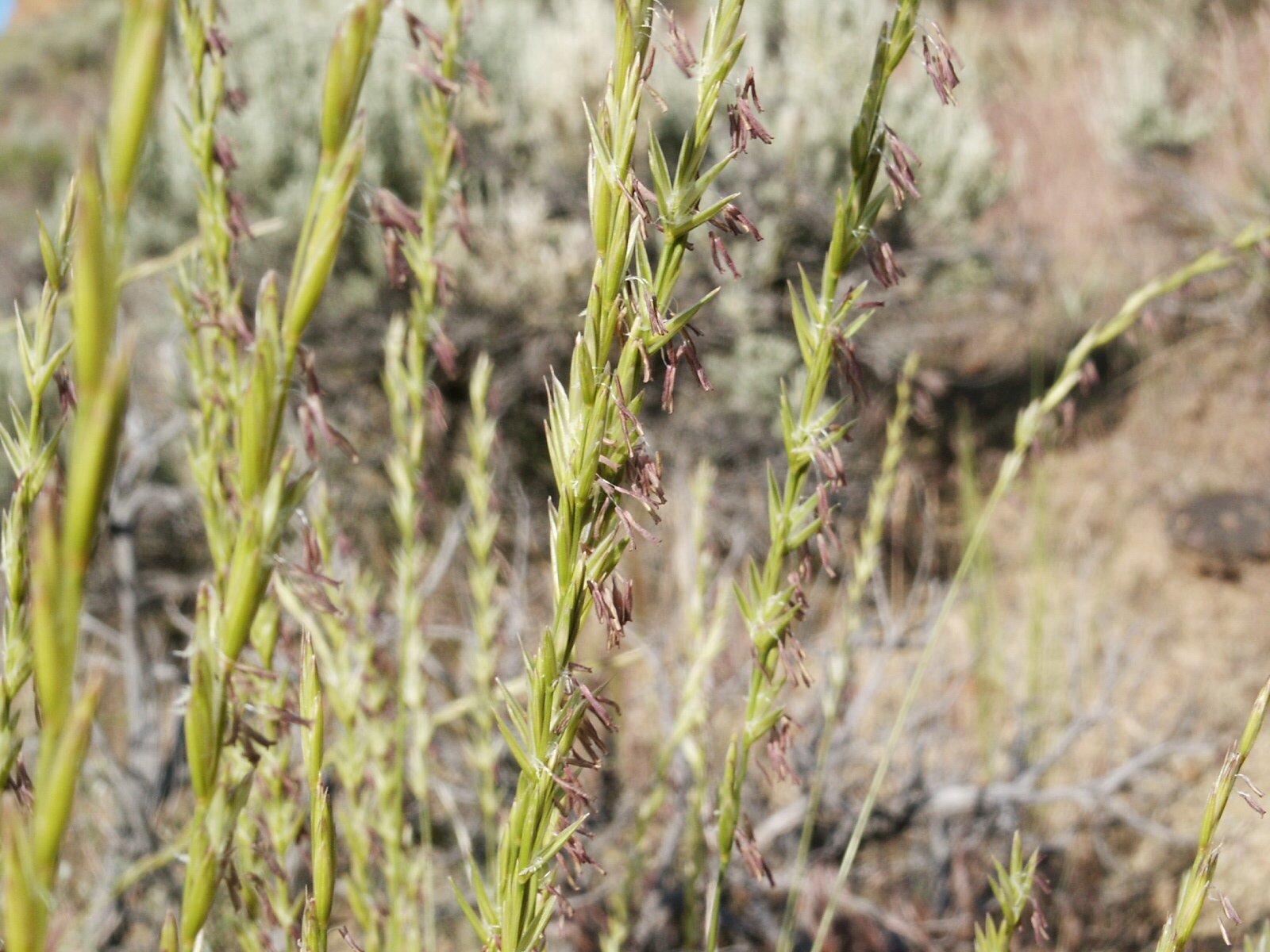 | 1973 | |
Fisch | Cutthroat-Forelle Blackspotted Cutthroat Trout (Oncorhynchus clarkii lewisi) |  | 1977 | |
Säugetier | Grizzlybär(Ursus arctos horribilis) | 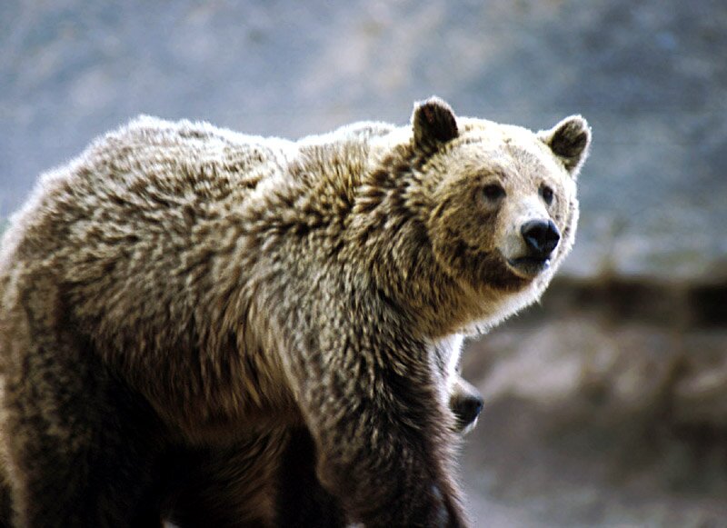 | 1982 | |
Fossil | Hadrosauridae (Entenschnabelsaurier), Maiasaura Duck-billed Dinosaur |  | 1985 | |
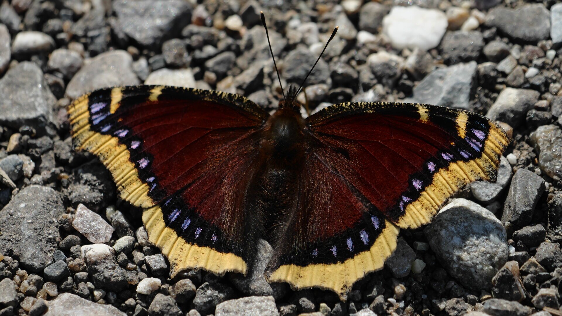
Schmetterling | Trauermantel Mourning cloak (Nymphalis antiopa) |  | 2001 | |
Bodentyp | Scobey | 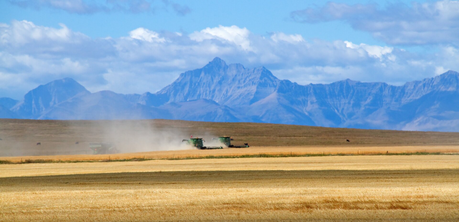 | 2015 | Seinen Namen hat der Bodentyp Scobey zwar vom gleichnamigen Ort im Nordosten Montanas, jedoch findet sich dieser Bodentyp vor allem im „Goldenen Dreieck“ (Golden Triangle) zwischen den Städten Great Falls, Havre und Conrad. |
Update: 08. + 10/11.02.2024
Quelle: https://de.wikipedia.org/wiki/Montana#cite_ref-6
[5]U.S. Census Bureau _ Census of Population and Housing. Abgerufen am 28. Februar 2011.
[6]https://www.census.gov/data/tables/2010/dec/apportionment-data-text.html